Most people know that the street names on the Woodley airfield development were inspired by the history of the site. They include names of planes: Hurricane Way, Spitfire Way, Viscount Way, famous aviators: Farman Close, Orville Close, Wright Close and people or companies who developed aeroplanes: Miles Way, Mitchell Way, Sopwith Close. The Museum of Berkshire Aviation has a 100-page folder of names on the airfield researched by John Wright. Therefore, this document will concentrate on the non-airfield names.
Woodley was a rural area for most of its history. Early maps show a recognizable pattern of roads, but without names. Where did the streets get their names?
Some names first appear in the 1550 Survey of Sonning, a legal document which detailed who owned land and houses in the parish of Sonning. Woodley was a part of Sonning until 1881 when the parish of Woodley and Sandford was formed. There were also Surveys of Sonning in 1611-18 and 1759-83. The 1820 Woodley enclosure map and awards and the 1843 tithe map also recorded early names. Both are in the Berkshire Record Office.
A 1915 Kelly’s street directory of Woodley shows that the only streets with numbered houses were 1-10 Denmark Avenue, which were numbered by the builder, and 1-3 South View Cottages.
At a meeting of Woodley Parish Council in 1931, the members discussed a request from the Post Office to display road names. Some of the roads had more than one name, often known by the name of the landowner or local resident, and this was making it hard to deliver letters and telegrams promptly. In 1932 they agreed to name the road from The Chequers to the Bath Road: Reading Road. The road from The Chequers to Cobbler’s City would be Headley Road. The road from Martin’s Corner (now the Just Tiles roundabout) to the Southern Railway bridge would be Loddon Bridge Road. The road from Martin’s Corner to the Great Western Railway bridge would be Butts Hill Road. Oak posts with boards with four- inch lettering in black on white would be erected to name these roads.
In 1936 Woodley Parish Council received a letter from Wokingham Rural District Council, (who were responsible for areas outside Wokingham town) asking for their views on the numbering of houses. The Parish Council replied that building was not yet advanced enough to need the numbering of houses.
In the 1940 Kelly’s directory, only the newer houses in Woodlands Avenue and Woodwaye were numbered. Houses in Butts Hill Road, Headley Road and Loddon Bridge Road had names but no numbers. Presumably local people knew where they were! In the late 1940s, Wokingham Rural District Council insisted that houses had numbers. The 1949 Kelly’s directory showed that most residents had complied, but some houses were still listed under a name not a number. The 1962 Kelly’s directory was the first one to list streets in Woodley in alphabetical order. Before that Woodley residents were just listed in alphabetical order by surname.
Addington Gardens was the way to Addington School when it was off Loddon Bridge Road. Addington School later moved to Woodlands Avenue. It was named after Henry Addington the speaker of the House of Commons and prime minister 1801-1804.
He lived at Bulmershe Court, also known as Woodley Lodge. For more information about schools, see the document The Growth of Education and Schools.
Ambleside Close was first listed in the 1962 Kelly’s directory. Beechwood primary school in Ambleside Close celebrated its 50th anniversary in 2020. For more information about schools, see the document The Growth of Education and Schools.
Antrim Road was built when the North Lake, formerly in the Bulmershe estate, was drained in 1960.
Arundel Road was named after the town and castle in Sussex. It had a dairy in the 1960s.Christ Church is on the corner of Crockhamwell road and Arundel Road. For more information about Christ Church, see the document Woodley Churches.
Austin Road Local residents remember that it had an air raid shelter for many years after the war.
Bader Way was named after Douglas Bader the flying ace and WW2 hero who famously lost his legs in an accident at Woodley Aerodrome in 1931.He was in the RAF and had been forbidden to do low flying stunts because of the danger of crashing the plane. His log book for that day records “Crashed slow rolling near ground. Bad show”. He was taken to the Royal Berkshire Hospital, but surgeons were unable to save his legs. In gratitude to the staff, he often visited the hospital to help with fund raising events in the 1950s. He opened Woodley’s Coronation Hall in 1956.
Bakers Way is off Millers Grove. They were both named after Parslows Bakery which was on this site from the early 1960s to 1982. Then it was taken over by Allied bakeries, who closed in 2006.
Beechwood Avenue is named on a 1938 Ordnance Survey map but there are no houses, just trees. It was an old carriage drive from the East Lodge (also known as Hurst Lodge) across the Bulmershe estate. The Beechwood Avenue Self Build Housing Association built their own houses here in the 1950s.
Beggars Hill Road
It was the way into the parish from the Bath Road towards the old workhouse at Cobblers City. The place name Beggars often referred to poor land or an unpleasant place (Gelling). Lands End House was built by architect Guy Morgan in 1934 for Frank and Blossom Miles.
Blossom Grove It is possible that the builders just liked the name Blossom Grove and its association with trees in spring.
Or it was named after Maxine Miles, wife of F. G. Miles the owner of Miles Aircraft Factory. She preferred to use the name Blossom. Daughter of a famous theatrical family, her first husband was a wealthy aristocrat who paid for her to have flying lessons at Shoreham in 1930. She fell in love with her flying instructor F. G. Miles and divorced her first husband to marry him. From 1934 they lived at Land’s End House.
She took an active interest in Miles Aircraft and was involved with design and testing of aeroplanes.
Bosworth Gardens was built by 1962.The name comes from the battle of 1485 between Richard III and Henry Tudor, later Henry VII.
Brecon Road
As each new housing development was built in Woodley, it included a parade of local shops. Sometimes a school was built too. There is still a parade of local shops In Brecon Road. In 1970 it had:
H. and D. Giles, newsagents and Post Office at 4 The Parade, Brecon Road.
Green Grocers at 3 The Parade
Hardware Centre 2 The Parade
In 2020 the shops are Mas News and Post Office, Lana’s barber and hairdresser, Want Want Chinese takeaway and Brecon Stores.
Brunel Drive
The chief engineer of The Great Western Railway from 1835-1859 was Isambard Kingdom Brunel.
Butts Hill Road
The first mention of this name was “a pightle by Butt Lane David Ilton” in the 1759-1783 Survey of Sonning. We know that David Ilton was a tenant farmer of Robert Palmer and the Holme Park estate. Butt Lane was shown as a road but with no name in the 1820 enclosure award and map for Woodley. “A cottage of Joseph Taylor at Woodley Green and cottage and garden of William Goodchild” are mentioned. It went from the westward corner of the old workhouse plat (plot) on what is now Headley Road East, to Phillis’ Hatch (now the junction with Duffield Road).
The 1843 Woodley tithes document mentions a “Butts Hill pightle” owned by Robert Palmer. The road was named by the Parish Council in 1932. Early houses had wells in the back gardens. It is not known why it was called Butts Hill Road. The Butts were where people went to do archery practice in the middle ages. Possibly the Butts was part of the medieval manors of Holme Park or Bulmershe. The Broad Street Mall was originally named The Butts Shopping Centre.
There were never any shops in Butts Hill Road. The 1940 Kelly’s Directory listed The Grange Guest House and Country Club, A. Greenhough proprietor, in Butts Hill Road.
Mrs Greenhough was the widow of the chief librarian of Reading Library. In 1945 the Parochial Church Council paid £4000 for the house to use as a vicarage for St John’s church. See also Church Road.
In 1949 Joseph Horne, nurseryman was in Butts Hill Road. Rural Crafts Fencing and Sheds had premises at the Sonning end of Butts Hill Road. The owner lived at number 33.
Caldbeck Drive was built in 1959.
Campbell Road has South Lake primary school.
Carlton Close first appears in the 1962 Kelly’s directory. The houses were built by Wimpeys.
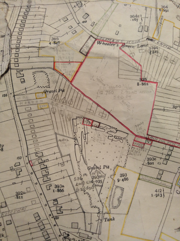
Chaffey Close off Colemans Moor Road was named after the Chaffey family who had a gravel extraction plant in Colemans Moor Road from the 1930s-1970s. For more information, see the document Work in Woodley.
Chequers Way was called after the pub, possibly from a local landowner’s coat of arms. It was the northern end of Crockhamwell Road where the shopping precinct is now. That name no longer exists in Crockhamwell Road, but there is a modern Chequers Way off Howth Drive.
Christian Lane
This went from Town Lane across the Bulmershe Estate to the Bath Road. In the 1759-1783 Survey of Sonning, George Blagrave who owned the Bulmershe estate, had a “small farm by Christian Lane”. The 1820 enclosure talks of a footpath “leading out of Christian Lane at the west corner of an old inclosure called Bromley’s and proceeding in an eastward direction across other grounds of James Wheble Esquire into Bullmarsh Heath … into Hurst Road at the Chequers Public House”. Hurst Road is now Headley Road. Christian Lane is no longer in existence.
Church Lane was shown on the 1820 enclosure map going from Town Lane to the Bath Road. The name is no longer in use.
Church Road was called Pucks Lane in the 1870s Ordnance Survey map. St John’s Church of England school was opened in 1855. After St John’s Church was built in 1873, the road was renamed Church Road. The church and school are listed buildings and part of the Woodley Green conservation area. The vicarage opposite was also built in 1873. During WW2 it became a day nursery, mainly for the children of Miles Aircraft employees doing essential war work. It stayed a nursery after the war. Berkshire County Council refused to hand it back and St John’s church had to find new accommodation for the vicar in Butts Hill Road. The Verger’s cottage next door became a Parish room and later a lending library. Robert Palmer built two pairs of cottages in Church Road. One pair was demolished but the other two cottages survive. See also Pucks Lane.
Clivedale Road first appears in the 1962 Kelly’s directory.
Cobblers City was not a road but an area at what is now the junction of Tippings Lane and Headley Road East. The name first appeared on maps in the mid 19th century and lasted until the 1950s.There is no evidence from the censuses that there was ever a cobbler there. It is thought that the name comes from the expression “cobble together” meaning doing something quickly or roughly, and refers to the kinds of work that people did, or the way the houses were cobbled together. The City was a nickname for small plots or settlements (Gelling). Appletree Cottage, Wishing Well Cottage and Bluebell Cottage are 17th century listed buildings. In the 1920 Kelly’s directory Robert Holly’s address was just Cobblers City.
Cobham Road was named after Sir Alan Cobham who brought his famous Cobham’s Flying Circus to Reading Aerodrome, also known as Woodley Airfield, in 1929.It was the first official event at the new airfield. The Mayor of Reading, local dignitaries and several thousand spectators came. 500 adults and 120 school children were given their first experience of flying. June Lloyd who lives in Loddon Bridge Road remembers when the road was previously a farm track leading to Richardson’s farm.
Colemans Moor Lane
Colemans Moor was first mentioned in Rentals and Surveys at the National Archives from 1603-4. It was part of Haywards Manor owned by the Vials or Vyells family. Colemans Moor was a farm which was demolished in 1970. There was a pond shown on the 1883 OS map. The farm was listed in the 1759-1783 Survey of Sonning and James Pearce was the tenant. In the 1848 Kelly’s Directory the farmer was John Manners. He was still there in 1874. By the 1880s William May was the farmer. According to the 1881 Census he farmed 270 acres and employed 5 men and a boy. The last famer was Mr A. Steel.
Richard Smith remembers that Colemans Moor Lane was formerly known as Wheelers Green Lane. The Post Office directory 1933 named it Wheelers Green Lane, then in 1934 it was Colemans Moor Lane. But Kelly’s directory 1932 had it as Colemans Moor Road, thus causing confusion to local postmen. It was shown on the 1933 Ordnance Survey map below as Wheelers Green Lane.
In the 1939 Kelly’s directory, George Iles, fried fish dealer, was at Lechlade, Colemans Moor Lane. The shop had gone by 1949. No shops are there now. His daughter Shirley still lives locally.
Colemans Moor Road was formerly known as Colemans Moor Lane from maps of 1870-1930.
In the 1931 Kelly’s Directory, Colemans Moor Road had two grocery shops. One was run by Hereward Summers, later by his widow Gladys. It was still in business at 140 Colemans Moor Road in 1960, and had gone by 1970. The other shop in 1931 was owned by Charles Atkins. It was no longer there in 1940. Richard Smith remembers that there was a greengrocer in an old shed down the road.
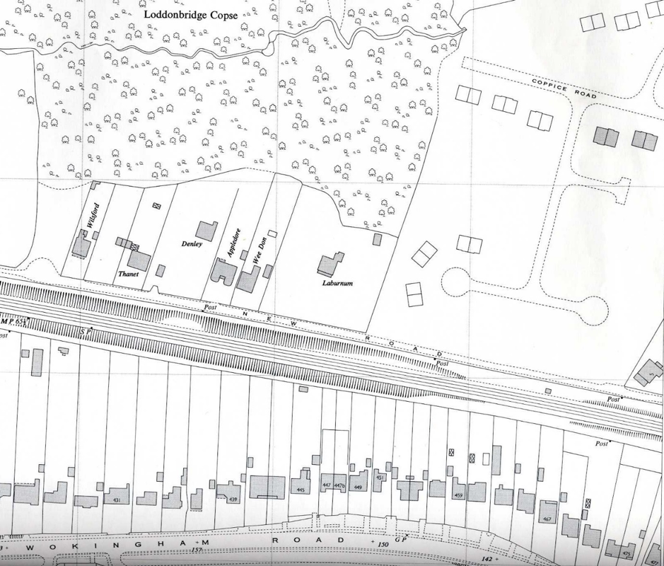
Coppice Road
There was a Coppice House on Loddon Bridge Road. William Mortimer lived there in 1935. Coppice Road first appears in the 1962 Kelly’s directory. A new parade of 10 shops was built for the estate. The 1970 Kelly’s directory listed:
The Parade
- Garner F C grocer
- Kelvinator Launderama
- McGready Angus
- Botibols newsagents
- Kevern C S butcher
- Rothstein Cyril and Sarana, ladies hairdresser
- Basket of Fruit greengrocer
7a Coppice Wine Store
- Empty
In 2020 the shops are: Balti Place, Premier Stores and PO (2 shops) – the PO is called Wheelers Green PO, Woodley Chef Chinese, 3 Chairs and a Barber, Richard Lloyd Funeral services (2 shops).
Copse Mead off Duffield Road had a few large houses in the 1935 Kelly’s directory. In the 1970 directory the houses still had names not numbers.
Corbett Gardens was first listed in the 1962 Kelly’s directory.
Crockhamwell Road
The name appeared in the 1759-1783 Survey of Sonning “A cottage and garden at Crookham Well near Bullmarsh Heath”. The 1820 enclosure award described, but did not name the road, as a “private carriage and drift road and public footpath” from The Chequers south east to Letts Green. A drift was a passage for cattle. There was a cottage on the corner where the road curves which was formerly part of the Bulmershe estate. It had a well in the garden and was shown on maps as Crockham Well. It is now called Rose Cottage and the current owner said that the well had been covered over. There are also 2 old cottages near the junction with Fosters Lane.
The 1939 Kelly’s directory had the 1st listing of a shop in Crockhamwell Road: Bertie and Beatrice Ambrose, fried fish dealer, Crockhamwell Road. It was there until 1970. Maxwells famous hardware shop was owned by Max Steggles. When the shopping precinct was developed, twelve council houses were pulled down. St John Bosco RC Church was built in 1948 on the site of the former East Lodge of the Bulmershe estate. It was demolished in 1967 and later moved to Western Avenue. The historic Chequers pub was replaced by a modern building. Shops were built in phases in the 1960s and 70s.For details see the document Shops in Woodley.
In 1963 a Methodist church was built at the corner of Crockhamwell Road and Arundel road. In 1982 the Methodists and the United Reformed churches merged and a new larger building was added. For more information see the document Woodley Churches.
Crossways first appeared in the 1962 Kelly’s directory.
Denmark Avenue
The 1915 Kelly’s directory shows that numbers 1-10 Denmark Cottages had been built. Mrs Deadman lived at number 10.
The 1939 Register tells us that Denmark Avenue had 23 houses, and 81 residents. The first 13 houses, with names not numbers, seem larger as they had more residents, and aircraft workers lived or lodged in these houses. Numbers 1-10 followed but had fewer residents. Denmark Avenue had 30 women – all listed as unpaid domestic duties, except 2 working on aircraft and 1 as an assistant in an ironmongers. 6 were widows and 1 biscuit packer was unemployed/ incapacitated, another 1 was incapacitated and one an invalid.
There were 27 men-15 of them were working at the aircraft factory.
There were 7 schoolchildren.
The specific jobs ranged from aircraft general labourer, detail fitter, rigger, tool store keeper, woodworker, paint sprayers, aircraft subcontractors, progress chasers, draftsmen. The two women were an aircraft fabric stitcher and a rib maker.
Max Steggles, the owner of Maxwell’s hardware shop in Crockhamwell road, lived at Cornerways in Denmark Avenue. Waingels Copse School, now Waingels College, was built in 1970 and lies between Denmark Avenue and Waingels Road.
Drovers Way
It was one of the old routes across Bulmershe Heath used to drive cattle and sheep to market. Houses were built in the 1950s and the name first appears in the 1960 Kelly’s directory.
Duffield Road
The name means a field with doves in it. It was a common place name and there are towns in Yorkshire and Derbyshire with the name Duffield. This was one of the old roads shown but not named on the 18th century Rocque map. It depicted a cluster of houses with the name Woodley along Duffield Road. The house called Wangels in Duffield Road is now called Woodley Lodge. It is thought to have been an 18th century farmhouse. Duffield House was built in 1930 and demolished in 1995 by Bewley Homes to build more houses. There was an archaeological excavation when Duffield House was demolished, which showed evidence that Bronze Age people were living in the area. The area known as Ray or Rag Castle was in Duffield road. Willow Bank Infant and Willow Bank Junior School are in Duffield Road. They celebrated their 50th anniversary in 2020. For more information about schools, see the document The Growth of Education and Schools.
Eastwood Road was first listed in the 1962 Kelly’s directory.
Englefield Place is part of the new development off Woodlands Avenue. The name comes from the Englefield family who lived at Whiteknights in Earley in the 17th and 18th centuries, and also owned land in Sandford.
Fairwater Drive
Highwood School in Fairwater Drive replaced the former William Grey Infant and Junior Schools. They were built in the late 1960s, were merged and replaced by Highwood in 1999. For more information about schools, see the document The Growth of Education and Schools.
Farriers Close off Reading Road was the site of the village forge. It is now a building used as a music room by a professional pianist who lives next door.
It had St John Bosco, Mater Misericordiae convent school, according to the 1962 Kelly’s directory. The school was in Reading Road before that.
Fawcett Crescent was first listed in the 1960 Kelly’s directory. The name honours Millicent Fawcett, who campaigned for women to have the vote.
Fosters Lane
The name refers to foresters and is in common use as a place name. A 1658 document in the National Archives has a place name Little Fosters in Woodley and Sandford. The 1820 enclosure award has “A private carriage and drift road… leading out of the last described road (Crockhamwell Road) in a north eastern direction into a lane between old inclosures of Robert Palmer esquire and Mathew Tully”. Heath Dairy was built as Heath Cottage and run as a small holding in 1818 by Mathew Tully (sometimes spelled Dully). By 1911 it was inhabited by The Chapman family running it as a dairy. The road was named Foster’s Lane on a 1883 OS map. There was a farm at the corner of Crockhamwell Road on the 1843 tithe map which was occupied by John Manners. It was sometimes called Foster’s farm or Richardson’s Farm and was demolished in 1950. Fosters Old People’s Home run by Berkshire County Council was in Fosters Lane for many years, replaced by the current building Fosters in 2018.
Frampton Close and Frimley Close were first listed in the 1962 Kelly’s directory.
Freshers Grove
This road is part of the new development off Woodlands Avenue which replaced Bulmershe College of Education, later part of Reading University.
The name, and the nearby Tutor Crescent, was inspired by the students and staff who were a part of Woodley’s history between 1964 and 2011.
Glendevon Road was built in the 1950s.The name comes from Glendevon, a picturesque glen in the Highlands of Scotland.
The 1933 Ordnance Survey map below shows the later line of Glendevon Road and Selsdon Avenue.

Grays Crescent was possibly named after William Gray or Grey who bought Bulmershe Manor from Reading Abbey in 1536.Or it was named after one of two vicars of St John’s church with the surname Gray: The Reverend E.A. Gray, vicar 1881-1913, or The Reverend Philip Gray 1925-30. It is at one end of Town Lane, the footpath to Pitts Lane.
Haddon Drive was built in the 1950s by the building firm Gough Cooper. The name comes from old English words for heather and hill. The same place name element is found in Headley.
Headley Road and Headley Road East
The name came from Hadleigh Heath. This was sometimes spelled Hadley, Hedly or Hedlye. The name means a clearing overgrown with heather (Gelling).The 1550 Survey of Sonning tells us that John Stedman had one piddle and Thomas Lovejoy had two and a half acres of arable land at Hedly. Hedly Piddle was mentioned in a document of 1603-4 in the National Archives. A piddle is usually spelled pightle, and was a small piece of enclosed land. Pightle is common as part of a field name on tithe and enclosure maps. Headley Road and Headley Road East were part of the old Hurst Road from The Chequers pub via Bulmarsh and Hadleigh Heath to Sandford Mill and Hurst. Headley Road was named on an 1883 OS map. The names Headley Road and Headley Road East were confirmed by the Parish Council in 1932.
The first shops in Woodley were in Headley Road. In the late 19th century, Aldridge’s shop and Post Office was in Cobblers City, near the junction of Headley Road East and Tippings Lane. The old workhouse, St Luke’s Home for Sick Children and the Working Men’s Club were all in Cobblers City. As late as 1938, the Ordnance Survey map showed the Workhouse Moor between Headley Road East and the vicarage in Church Road.
1931 Kelly’s directory lists:
Albert Lee grocer Headley Road Tel Sonning 2 and Chas Taylor and Sons butchers. By 1935 the butcher was run by Francis Bros and another grocer Bernard Hemsworth had opened. Also Percy Lee boot repairer, Vera Munday draper (by 1939 the draper was Mrs Dora Lawes), Fras. Salter drug stores (by 1939 it was Woodley Pharmacy, run by Miss Z.H. Novack), Robert Storr, cycle agent and Wilfred Ward, hairdresser.
Patricks drapers, proprietor Mrs D. Lawes was at Wayside in Headley Road. Bernard Hemsworth’s grocery shop was Waverley Stores and it was the agency for Thames Valley Traction (the local bus company) parcels.
Robert Edwin Storr, cycle repairer was at Clanfield, Headley Road.
The Co-Op was near the junction with Crockhamwell Road and International Stores was at what is now the Just Tiles roundabout.
Phillips and Powis, later Miles Aircraft had their aircraft factory in Headley Road East from 1929-1947. Then Handley Page ran it from 1948-1963. It later became an industrial area with companies like Lebus furniture and Adwest engineering. See the document Work in Woodley for more details.
Lone Pine Cottage, an 18th century listed building is in Headley Road near the junction with Reading Road. It was the home of Elizabeth Simmonds who used to work at Woodley library and wrote a book The Woodley Album. It is now occupied by Three Way Physiotherapy.
Hearn Road The 1962 Kelly’s directory listed a grocer shop run by A.G. Whitten at 9 Hearn Road.
Katherine Kellman, who posted in 2019 on Memories of Woodley Facebook group, remembered a Mace store on Hearn Road off Drovers Way. It sold sweets, cigarettes etc. It was run by Mr and Mrs Lee in the 1960s, then Mrs Baker, then by Mick and Val Day.
Howth Drive
Named after Howth Castle near Dublin. James Joseph Wheble owned the Bulmershe estate from 1840-1884. He married Catherine St Laurence, daughter of the 3rd Earl of Howth.
Howth Drive has a shop at no 64; T. T. Edwards newsagent. It is remembered as Terry’s by people on Memories of Woodley. It used to have a pub The Woodley Yeoman. Kelly’s directory lists the pub at 60 Howth Drive in 1968 and it closed in 1983 or 84. The Woodley Yeoman had an off licence which was popular with Bulmershe pupils. Yeoman Place was built on the pub site. Douglas Bader Court, built in 2008 and Woodlands Court built in 1980, both retirement homes, are in Howth Drive.
In the 1970 Kelly’s directory was Catherine Court Home for the Aged at 120 Howth Drive. It was replaced By Douglas Bader Court.
Hudson Road is off Colemansmoor Lane
In 1966 the road was listed in Kelly’s directory with houses but no shops. The 1972 Directory has no. 2 Baylis Supermarkets Ltd, grocers; 4 A. and J. Abdale newsagents; 6 Copper Stick, self-service laundry.
The radio DJ Pete Murray opened the supermarket in Hudson Road in 1976.
The 1976 directory listed: 2 Hudson Road Oakeshotts, grocers, 4 newsagents, 6 Copper Stick.
In 2020 it had the Moonlight Indian takeaway, Hair of the Dog grooming parlour,
Laz Tadim pizza (closed) and Londis convenience store
Keswick Gardens was first listed in the 1962 Kelly’s directory.
Kingfisher Drive has Southlake Parade near St James Church, with a convenience store and hairdresser. Some of the shops in the parade became houses. St James Church Centre was built in 1974 to serve the South Lake estate. For more information about churches, see the document Woodley Churches.
Knowle Road was first listed in the 1962 Kelly’s directory. The name comes from the Anglo-Saxon word “Cnolle” meaning a small hill.
Ladbroke Close off Vauxhall Road
It used to be an industrial area which backed onto the factories in Headley Road East. Forley Printing Co, Cippoint Design Co. and Cippoint Engineers had premises there in the 1970s. The road is now residential.
Land’s End
Refers to land on the boundary between two landowners (Gelling). The Land’s End pub was first mentioned in Kelly’s 1847 directory. It is now The Heron on the Ford. The nearby Giddy Bridge was mentioned in the 1611-1618 Survey of Sonning, a legal document which detailed land ownership.
Letts Green Road was on the 1820 enclosure map in part of what is now Loddon Bridge Road. It went from The Good Companions to the junction of Colemans Moor Lane. Letts Green was one of the clearings in the wood or marsh like Woodley Green and Norris Green. It was named in the 1759-1783 Survey of Sonning “A house of two tenements and other buildings, a wheelwrights shop and garden at Letts Green”. Edward Simmons and William Caplin were the tenants. In the 1930s it was known as Wheelers Green. There is a modern close called Letts Green off Crockhamwell Road.
Lismore Close is off Coppice Road. There are places in Ireland and Scotland called Lismore. It lost many houses when the A329M was constructed.
Little Hungerford was a part of the Bulmershe estate until it was sold in 1926. The name came from the wife of John Blagrave who was called Anne Hungerford. He inherited the estate in the 16th century. The 1759-1783 Survey of Sonning mentions “cottages and gardens called Little Hungerford by Bulmarsh heath”. Hungerford Lodge was a 6 bedroom house near Earley Station which had been called Earley Cottage. It was between the Wokingham Road and the Reading to Reigate (later Southern Railway) line. Captain James St Laurence Wheble sold the big house, Bulmershe Court. Captain Wheble renamed Earley Cottage, Hungerford Lodge when he moved there with his brother Major Tristram Wheble in 1912. They both died in the 1920s. The 1938 Ordnance Survey map shows Hungerford Lodge still there. It was later demolished for housing and Stanton Road was built. The name Little Hungerford was used as a local council ward name from 1974-2004.

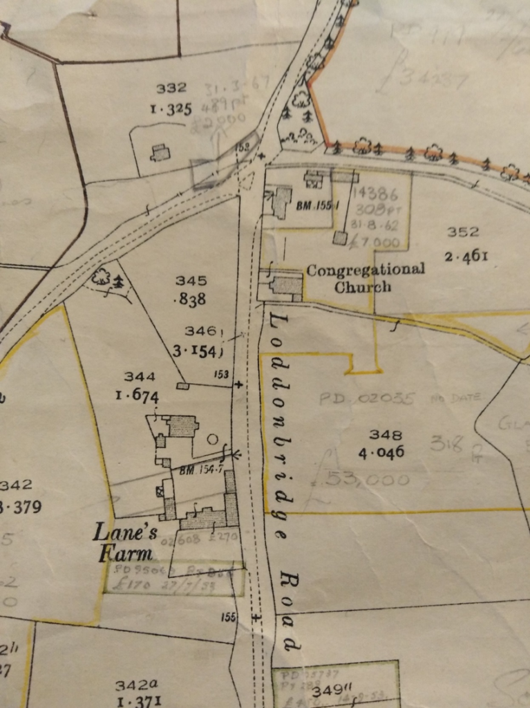
Loddon Bridge Road was named by the Parish Council in 1932. Early forms of the river name were River Lodena 1190, Lodene 1227, Lodona or Lodyn. Bridge of Loden 1263 (Gelling, National Archives). It possibly means a muddy river but there is no proof (Gelling). Loddon Bridge appeared on early maps of Windsor Forest. Fishing rights on the river were important. The 1550 Survey of Sonning said that John Barfoote had “one fishing place lying beneath Loddon Bridge containing in length 11 perches”. The road was shown but not named on the Rocque map of Woodley in 1763.In 1820 Edward Goodchild lived in Woodley Cottage, Loddon Bridge Road, opposite the end of Fosters Lane. The cottage is still called Woodley Cottage.
The 1933 Ordnance Survey map below shows Lane’s Farm at the corner with Fosters Lane.
In the 20th century Loddon Bridge Road had local shops:
The 1935 Kelly’s directory listed William Byford and Son, butchers at 134 on the corner of Norton Road. It was still a butcher’s shop, owned by William Davies in 1970. In the 1949 Kelly’s directory, Arthur Thompson, grocer was at 132 Loddon Bridge Road next to Davies butchers.
The shops at the corner of Norton Rd are now 2 estate agents and Freelance Carpets.
Mortimers’ Store at 186 was run by William Mortimer, then later by Sheila and Ron Kernutt. It was a grocers and Post Office on the site of the old village pond at Wheelers Green (now Berkshire Bicycles).
In 1939-40 Harry Lee was a newsagent at Caroline, Loddon Bridge Road. It was also the receiving office for Woking Steam Laundry Co. and the rival Wokingham Laundry Co. Esther Slade was a shopkeeper, Miss Ivy Simmonds had a shop called Casanova and S.W.Farr ran the off licence in Loddon Bridge Road – but we do not know where in the road these shops were, as none of these shops had a street number.
Jesse Goffe ran the Post Office and grocers, tobaccconists and confectioners at 143 Loddon Bridge Road. In the 1960s it was known as Bulmershe Stores. This was in the parade which now has The Good Companions pub. The pub was built in the 1950s. In 2019 next to The Good Companions are Salt and Vinegar fish and chip shop and Finn Hairdressers.
165 Loddon Bridge Road, opposite Colemans Moor Lane, is called Rolling Stones. It was the home of Linda Lawrence who was the girlfriend of Brian Jones of The Rolling Stones. They used to practice in her home before they became famous. After his death she married the pop singer Donovan. Her brother Stewart played in a well-known band in the 1960s.
Cedar Place retirement flats at 231 Loddon Bridge Road near the Just Tiles roundabout, is managed by the Woodley, Sandford and Charvil Trust. They were built with money from the Poor Lands Charity, which used to own the allotments on Headley Road East. The allotments site was sold for development.
The Congregational Church (later United Reformed) in Loddon Bridge Road was built in 1834. The building closed to worshippers in 1982 when the United Reformed church merged with the Methodists. It was Laflins estate agents and is now occupied by Creative Digital Strategy, an IT company.
Lunds Farm Road was called after the farm which was here. William Lunn was a tenant farmer at the time of the 1820 enclosure of the Palmer estate. John Lunn was a farmer at Woodley Green in the 1848 Kelly’s Directory. By 1898 the farmer at Lunn’s Farm was George Bassett. In the early 20th century it became Lunds Farm. In the 1930s Lunds Farm was farmed by the Pither family who also farmed Woodley Green Farm. Houses were built in the 1970s.
Lytham Road
This was built on the site of an old market garden to give access between Crockhamwell Road and Headley Road when the shopping centre was pedestrianized.
Malvern Close has houses built by Wimpeys. In 1970 a 3 bedroom semi-detached house was offered for sale in the local papers for £5500.
Manners Road off Wheble Drive had houses built by 1962. It was probably named after the Manners family. William and John Manners were local farmers in the 19th century.
Martin Close was first listed in the 1962 Kelly’s directory.
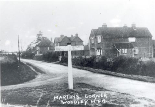
Martin’s Corner was a crossroads until 1941.It was at the junction of Headley Road and Headley Road East with Loddon Bridge Road and Butts Hill Road. It was made into a roundabout due to increased wartime traffic at Woodley Airfield. The name Martin’s Corner appears on maps and census records from the 1870s until the 1950s.
Some houses at the north end of Loddon Bridge Road had Martin’s Corner as their postal address in the 1871 census. The name disappeared in the late 20th century and it is known as the Just Tiles Roundabout today. It is thought that it was named after the Martin family who owned land in Woodley in the early 19th century. They are buried in Sonning Churchyard. Or possibly after James Martin, who was a tenant of James Wheble of Woodley Lodge, at the time of the enclosure. The 1861 census listed Martin’s Road which was from Martin’s Corner along Loddon Bridge Road to Fosters Lane.
Maxwell Close
Named after Maxwell Steggles who ran Maxwell’s hardware shop in Crockhamwell Road from the late 1940s to 1995. He was on Wokingham Rural District Council and was one of the people who started Woodley Carnival to raise money for a youth centre.
Millers Grove
Off Loddon Bridge Road, it was named after Parslows bakery which was there from the 1960s to 1982.It was taken over by Allied Bakeries which closed in 2006.Bakers Way is off Millers Grove.
Mulberry Close, Munro Avenue and Nightingale Road were first listed in the 1962 Kelly’s directory.
Mustard Lane
This first mention of Mustard Lane was in the Survey of Sonning 1759-1783. A parcel of land by Mustard Lane was farmed by David Ilton, a tenant of Robert Palmer who owned the Holme park estate. It was an unnamed road on the 1820 enclosure map and award. It went from The Chequers pub up the London Road into what is now Western Avenue and across the line where the Great Western Railway would be built in the 1830s, then it joined Pound Lane. It was named on a 1883 Ordnance Survey map. Robert Palmer built five pairs of cottages in Mustard Lane. By 1910 the southern end of Mustard Lane had been renamed Western Avenue. It was named after the Great Western Railway. Mustard Lane is now a cul de sac off Pound Lane and famous as the home of former prime minster Theresa May.
New Road
This road went from Loddon Bridge Road along the railway line in the direction of Earley station. In the 1950s houses were built on the north side of the road and they backed onto Loddonbridge Copse. The road disappeared in 1972 when the A329M was constructed.
Norton Road
This was built in the 1930s. It was originally going to be Pitts Road, but the Parish Council felt this could be confused with Pitts Lane on the west side of Woodley. The builder Mr Hillier agreed to change it to Norton Road. There was a VE Day party there in 1945.
Norris Green is the area round the main gate of Waingel’s College. The name comes from William Norris, a tenant of Robert Palmer, who owned a “house and garden at Butlers Green and a pightle adjoining” in the 1759-1783 Survey of Sonning. It is likely that Butlers Green came to be known as Norris Green after William Norris. Robert Palmer built four cottages at Norris Green.
It is now part of Waingels Road. Opposite Waingels College are 2 cottages, one of which has the number 3 Norris Green. See also Waingels Road.

The Orangery
This is part of the new development along Woodlands Avenue which replaced the Bulmershe campus of Reading University. The name comes from the Orangery of Bulmershe Court, the old mansion pulled down in 1962. It was replaced by Bulmershe College, which in turn was demolished after the university closed the site in 2011.
Pearson Way
Named after the Reverend Mr Hugh Pearson, vicar of Sonning 1842-82.
Perimeter Road went round the edge of Woodley Aerodrome. After Miles Aircraft, then Handley Page closed, many local industries such as Adwest and Lebus Upholstery had premises there in the 1970s.For more information see the document
Work in Woodley.
Pitts Lane houses were built during the 20th century, but the line of the road is older. It forms the western edge of Woodley.
Players Green was built in the 1950s.Woodley had a series of old greens: Woodley Green, Norris Green, Letts Green and Wheelers Green. But the name Players Green does not appear on old maps and documents. It was probably named after the Player sisters who lived at The Warren in the early 20th century and gave their time and money to local groups and charities. In May 1958 The Reading Mercury newspaper reported the death of Daisy Brooks of 12 Players Green who was killed crossing the railway line between South Lake woods and Henley Wood Road.
Pond Head Lane the name came from Pond Head Wood, on the Bulmershe estate between South Lake and the railway line. One of the lodges at the entrances to the estate was at Pond Head by the railway bridge. The building of the Reading to Reigate railway, then the A329M road, cut it off from the rest of Woodley.
Pound Lane was an old lane leading to Sonning. A pound was an enclosure used to keep stray farm animals safely in a village.
Pucks Lane
This was named after Pucks Farm which was here in the early 19th century. There was a dame school at the farm. In 1855 St John’s Church of England primary school was built here. After the church was built in 1873 the lane was renamed Church Road.
Rag Castle
The 1843 Woodley Tithes document stated that Ray Castle Fields were owned by Robert Palmer, with William Lunn the tenant. Rag Castle appears on the 1883 and the 1930s Ordnance Survey maps of 6” to the mile. See also Duffield Road.
Raleigh Close was first listed in the 1962 Kelly’s directory.
Ravensbourne Drive
Was built in the 1950s on the site of Skinners Copse. Mark Ballard of Memories of Woodley Facebook group remembers “All of the estate Ravensbourne, Haddon & Rowan Drive etc, were developed by Gough Cooper. Rowan Drive was developed in stages, so the road ended by number 32 in the first stage, when my parents moved in during 1956”.
In the 1970 Kelly’s directory it had a parade of 4 shops including:
Gawley butchers 49/51 and New Vogue ladies hairdresser at 45.
Only the middle 2 are still shops (2 shops were converted to flats): Bargain Food and Wine and Watsons Service Centre Panasonic, now closed.
Reading Road
The road from the Chequers pub to the Bath Road was named by the Parish Council in 1932.In 1940 Edward Terry was a chimney sweep at Blacksmith’s, Reading Road.
There are two listed buildings: the 16th century Bulmershe Manor at 105 and Olden Oak at 103, a 17thcentury house. Mr J. W. Dodgson lived at St Davids in WW2, later numbered 93. He was a retired chemistry lecturer from Reading University who wrote a diary of WW2 and the years after it. For more information, see the document
Woodley in WW2.
Near the junction with Western Avenue is Woodley Park, a small industrial estate. The 1940 Kelly’s directory listed New Era Homes, builders there. In 2020 the companies there are Total Tyres, Tara Neil Kitchens and Bathrooms, Cistermiser, Thorngate Upholstery, Kefron and Brightons Newsagents depot.
The Ridgeway was an access track to a farm called Cottage Farm located roughly where Nightingale Road is now. The track went past the edge of Loddonbridge Copse and was the location of what is now Coppice Road. When the plots along The Ridgeway were sold off in the 1920s by the farmer he retained the interest in the access track. The plots were large to cope with self- sufficient smallholdings. Over the years all have been subdivided to provide for more dwellings. When he eventually sold his surrounding land in the 1960s for the development of Keswick Gardens and Eastwood Road the developer also bought the line of The Ridgeway.
The road is owned by Twigden Holdings and it is the responsibility of the residents to pay for maintenance. Before 1968 it was gravel. It was covered in tarmac in 1968 and 1981.Wokingham Council has not adopted it. There is a Residents Association.
The Ridgeway still has a rural feel to the road.
Rochester Avenue was built by Gough Cooper in the 1950s on the site of Skinners Copse.
Roslyn Road was built in the 1950s.It was named after Roslyn with its famous chapel near Edinburgh.
Rowan Drive see Ravensbourne Drive above.
Ryecroft Close was built in the 1950s.
Sandford Drive
Is off Duffield Road. In 1934 the Parish Council tried to get the builders Soutter and Soden to change the name to Duffield Drive. They felt the name was misleading as Sandford Drive was nowhere near the Sandford part of Woodley and Sandford Parish. The builders refused. Sandford refers to a dry ford or river crossing. The 1550 Survey of Sonning mentions John Browne of Sanford and tells us that “Ralph Thomson holds by indenture dates 1st May 1522 one watermill called Sandford Mill”. Sir Francis Englefield held certain lands at Sanfordes.
Sandford Mill the 1759-1783 Survey of Sonning states that Robert Hudson, a tenant of Robert Palmer, had “a House being an Alehouse with a Garden and Pightle adjoining” on land near Sandford Mill. For more information, see the document on Sandford Manor and Mill.
Seaford Gardens was first listed in the 1962 Kelly’s directory.
Selcourt Close was built in the 1950s.
Selsdon Avenue was built in the 1950s. Selsdon is an area of Croydon with a luxury hotel converted from an old mansion called Selsdon Park.
Shepherd’s Hill used to be called Sonning Hill. The 1759-1783 Survey of Sonning stated that John Bagnall, the owner of Earley Court, had “The Shepherd Alehouse Yard and Garden in Earley”. The tenant was Robert Crook. There was a shepherd’s hut shown on 19th century Ordnance Survey maps at the bottom of the hill, near Shepherd’s House Lane and Suttons Seeds roundabout.
The inquest for the Christmas Eve 1840 railway accident in Sonning Cutting was held in Shepherd’s House and Isambard Kingdom Brunel attended.
“The room where the jurymen Etc., were accommodated is situated at the back of the Shepherds House, public house, and was erected for the convenience of the Railroad labourers engaged in the Sonning Hill a few years ago; this is about a half mile from the spot where the accident happened.” This is from the Reading Mercury inquest report in 1841 . The original pub was mentioned in newspaper articles in the 1850s-1871. It was variously described as near Sonning, or on the London road, Earley. After 1871 it seems to have gone out of business.
In the 1930s a new Shepherds House pub was built at the top of the hill.
There used to be a police station at Shepherd’s Hill.
1931 Kelly’s directory: Mrs Ethel Hannan shopkeeper and sub Post Office. In 1939 Harry Saunders had taken over.
Shepherds Hill, Sonning Cutting had a garage with a café, and a filling station near Shepherds Hill.
In 1939 there was the Green Monkey road house, Wee Waif service station and road house along the Bath Rd. George Pittock, grocer was at 392 London Road and Albert Smith, fruiterer 394 London Road. Everybody’s Café at 24 Shepherds Hill was owned by A. J. Chard.
1960 Albert Saunders, (possibly a son of Harry) was a shopkeeper and had the Post Office at 404 London Road. In 1970 it was run by A. R. Wilson.
Silver Fox Crescent was first listed in the 1956 Kelly’s directory. Houses had names not numbers.
South Lake Crescent
The road was first listed in the 1954 Kelly’s directory. It was named after the South Lake on Bulmershe Estate. The Woodley and Earley Society campaigned to keep South Lake as a recreational area. A man was fined for being drunk in South Lake Crescent in May 1958, according to the Reading Mercury newspaper. In 1960 the North Lake was drained and filled in. Emmanuel Church was founded in St John’s Church Hall in 1991. For more information see the document Churches in Woodley.
Steggles Close
Sussex Gardens first appeared in the 1962 Kelly’s directory.
Tippings Lane
The first recorded use of this name is in the 1759-1783 Survey of Sonning. It gives the name William Tippens as a former tenant of Robert Palmer. It is likely that he rented property on the lane now known at Tippings Lane. Names often changed over time, such as Lunn’s and Lund’s Farm. He also owned half an acre of Woodley Field and was a tenant on the Poors Land on Headley Road. The name Tippings appears on the 1883 Ordnance Survey 6” map of Woodley. The lane used to continue eastwards to Eleven Elms. This part of the lane has disappeared under the Airfield development. There were only 6 houses in Tippings Lane listed in the 1962 Kelly’s directory. The junction of Headley Road East and Tippings Lane is where Cobblers City used to be. It was the first built up area of Woodley. See also Cobblers City.
Town Lane
It was an old road across Bulmershe Heath shown on a map of 1810. It went from Christian Lane, near the North Lodge of the Bulmershe estate to The Chequers. Beechwood Avenue runs along part of it.
Today Town Lane is a footpath and it is not named at either end. It joins Pitts Lane and Grays Crescent and runs between the back of Bulmershe School playing fields and Reading Road Allotments.

Vauxhall Drive An air raid shelter was built in what is now Vauxhall Drive. It was one of the shelters built round the perimeter of Woodley Aerodrome. It survived into modern times and local people remember playing there as children.
Waingels Road
Often spelled Wangels or Wengell on early maps. The name is based on angel – a bringer of good news (Gelling). There was a Wangels copse and moor. The first mention of the name is in the 1550 Survey of Sonning, a document which recorded land ownership. It said that William Barrefoote had a cottage in Wangelfeld. The name is also spelled Wangell, Wengell and Wangle in the same document. In the 1882 OS map it was shown as Wiscombe Lane. Waingels Road originally ended in a T junction where it met Beggars Hill Road. In 1960 Gordon Yeomans lived at 1 Norris Green, Waingels Road. Norris Green was the area near the gate of Waingels College. In 1962 there were 10 houses. One and Two had numbers, the other 8 had only names.
Waingels Copse School was built in 1970 to replace the old Woodley Secondary Modern School. It is now called Waingels College and has 1500 pupils.
Warren Road is named after The Warren, a house which was part of the Holme Park Estate in Sonning owned by Robert Palmer. Presumably there was a rabbit warren as part of the estate in the middle ages. The 1820 enclosure described an “ancient lane leading to the London and Bath Turnpike opposite the direction post at Sonning Lane end”. In 1934 Wokingham Rural District Council asked Woodley Parish Council to name the road from Western Avenue to the Bath Road, Upper Sonning Lane. The road had been known locally as Warren Road for years, and the Parish Council decided to keep the name. The Miss Players lived in The Warren. Margaret died in 1923, Eliza in 1941 and surviving sister Grace sold the land in 1945. James Cook, a local builder, bought land and built houses in the 1950s.
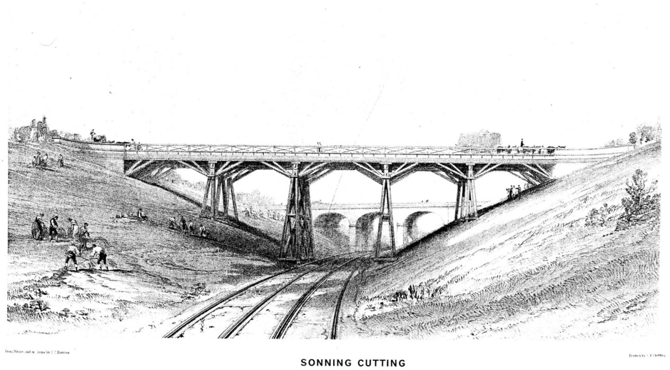
The picture is of the original bridge which carried Warren Road over Sonning Cutting. In 1893 the Great Western railway converted from broad gauge to standard gauge. The cutting was widened and deepened to take 4 tracks and the bridge was altered to the one we know today.
Western Avenue
The name comes from the nearby Great Western Railway line. It has attractive brick houses with ornamental brickwork. They date from before The First World War. It was originally a short stretch of road from Reading Road to Warren Road. The remainder was called Mustard Lane. By 1910 the southern end of Mustard Lane had been renamed Western Avenue. The 1920 Kelly’s directory lists it as The Avenue.
The 1931 Kelly’s directory tells us that William Russell had a confectioner’s shop, and Charles Hyde was a shopkeeper in Western Avenue. In 1940 there was an Avenue Garage, prop. Mrs E. Hussey, motor engineers.
Avenue Stores,47 Western Avenue was a grocery shop owned by Mrs Mary Webb in 1939, by Mr G. Balmforth in 1960 and Mr Lee-Knight in 1970. Mr Dodgson who lived in Reading Road, and wrote a diary of life in WW2, shopped there. He particularly liked Mrs Webb’s sausage rolls. In 2020 the shop is Parrot Studio, a hairdresser.
In 1962 the house numbers went up to 62 on the east side and after that it was names only.
St Dominic Savio junior school opened in 1965. The new St John Bosco RC church was built in 1970 to replace the former building in Crockhamwell Road.
Wheble Drive was named after the Wheble family who owned the Bulmershe estate for most of the 19thcentury.
Wheeler’s Green was at the top end of Loddon Bridge Road, between Fosters Lane and the Just Tiles roundabout. The 1920 Kelly’s directory gives addresses in Wheelers Green.Wheelers Green Lane was renamed Colemansmoor Road in the 1930s.
Wingate Road was first listed in the 1962 Kelly’s directory. The name means windy road, from the Norse geat for road.
Woodlands Avenue was first listed in the 1940 Kelly’s directory. Bulmershe Court was derelict after WW2 and was demolished in 1962.The Bulmershe College of Education was built on the site and opened for teacher training in 1964.Then it expanded its courses to include BAs in arts and humanities subjects and social work courses. From 1975 it was known as Berkshire College of Education. In 1989 it became part of Reading University and closed in 2011 when Reading University moved out. Bulmershe School was built in 1964 as a grammar school, and became comprehensive in 1968. The Bulmershe Lesiure Centre was built in the 1970s by Wokingham Council. It was completely rebuilt and reopened in 2020.
Addington Special School moved there from its former home in Addington Drive (now Rivermead primary school).
There is still a Bulmershe Court bus stop in Woodlands Avenue.
Woodley Green, off Church Road
It was one of the original greens in Woodley and the name first appears in the 1611-1618 Survey of Sonning. Woodley Green was shown in the Rocque map of the 1760s. In the 1962 Kelly’s directory 6 houses were listed by name and The Bull and Chequers pub was under Woodley Green.
Woodley Green became Woodley’s only conservation area in 1990. St John’s church and the 1855 former primary school are listed buildings. The vicarage and Church Mews are also in the conservation area. The Wokingham Council conservation leaflet described Church Mews as “a good example of sensitive modern development that fits well within the conservation area respecting the style, character and scale of the older buildings, and their settings”.
Woodley Lane
The 1759-1783 Survey of Sonning described a road called Woodley Lane. “A Farm called Midwinter by Woodley Lane” was farmed by William Caplin. It was called Woodley Road in the 1820 enclosure documents. In the 19th century Reading Road was also known as Woodley Road. This seems not to have been the same road as Woodley Lane. It went from Edward Goodchild’s cottage in Loddon Bridge Road opposite Fosters Lane (now Woodley Cottage) along what is now Butts Hill Road, then up Church Road to Woodley Field, the junction of Duffield Road and Tippings Lane. Woodley Field was bounded by Duffield Rd on the west, Denmark Ave on the east, Tippings Lane on the south and Rag Castle and Wangel (now spelled Waingel) Field to the north.
Woodwaye and Woodlands Avenue were shown as dotted lines on the
Ordnance Survey map of 1938. They were planned but not yet built on. In the 1950s the Self Build Housing Association built houses on Beechwood Avenue and Woodwaye.
Woodyer Close
Named after Henry Woodyer, the architect of St John’s Church.
Wroxham Road was built in the 1950s. Wroxham is a village in Norfolk, sometimes called the capital of the Norfolk Broads.
Wyndham Crescent was built in the 1950s. Molly Woodley remembers her bungalow on the corner of Wyndham Crescent and Wroxham Road. Two houses in Wroxham Road were demolished for access to the new estate in 1953. One was a poultry farm.
She paid £500 for the ground. Cooks the builder charged £2800 to build a bungalow, which had 2 bay windows at front. It was designed by an architect friend. The others were all estate houses. Electric sockets cost £5 each, so there was only 1 per room in her house.
It sold for £400,000 in 2010.
Yeoman Place off Howth Drive was named after the Woodley Yeoman pub, which was called after the volunteer cavalry regiment of the Napoleonic Wars. They used to drill on Bulmershe Heath. The pub was owned by Whitbreads and was there from 1968-1984 or 85.
Sources:
Ian Couper, The Survey of Sonning 1550, Survey of Sonning 1611-18, Survey of Sonning 1759-1783, Woodley enclosure map and awards 1820, Woodley tithe map 1843.
Margaret Gelling
Place Names of Berkshire
Kelly’s Street Directories
Wokingham Council
Woodley Green Conservation Area 1990
Michael Mitchell and The Ridgeway Residents Association
Oral communications by Joy Pibworth and many other residents of Woodley
1933 Ordnance Survey maps with later roads added were loaned by Michael Mitchell
Reading Mercury newspapers at Reading Central Library.